A team led by Wang Fang from the College of Architecture and Landscape , in collaboration with other researchers, reveals the long-term tension between the spatial patterns of early settlements and adaptation to hydrological conditions
Rivers, lakes, and wetlands provided early human settlements with the resources necessary for agricultural production, fishing and hunting, transportation, and daily life, but they also posed long-term risks such as floods, droughts, and water level fluctuations. The relationship between this “water-oriented development” and “risk-avoidance adaptation” is a key issue in understanding the sustainability of early cities. Previous studies have highlighted the crucial role of water management infrastructure in the social complexification and urban formation of early societies; however, a systematic, long-term explanation remains lacking regarding how settlement spatial patterns co-evolved with the hydrological environment and whether spatial expansion necessarily implies enhanced adaptive capacity.
To address this issue, a team led by Professor Wang Fang from the College of Architecture and Landscape and the Research Center for Watershed Human-Environment Systems at Peking University, in collaboration with the College of Urban and Environmental Sciences at Peking University, the College of History at Wuhan University, the College of Archaeology and Museology at Peking University, the College of Architecture and Planning at Shenzhen University, the Institute of Archaeology at the Chinese Academy of Social Sciences, and the Hubei Provincial Institute of Cultural Relics and Archaeology. Taking the Jianghan-Dongting Basin in the middle reaches of the Yangtze River as their study area, they established an early settlement spatial database covering 2,106 settlement sites from 8.5 ka BP to 2.72 ka BP and systematically analyzed the long-term relationship between settlement spatial evolution and hydrological adaptability. The research findings, titled “Tension between spatial pattern and hydrological adaptability in early Yangtze River Basin settlements,” were published in *Nature Cities*.
The study found that early settlements in the middle reaches of the Yangtze River underwent a transformation from relatively dispersed, isolated settlements to a system of settlement clusters featuring fortified sites, hierarchical structures, and regional centers. Diverse hydrological adaptation strategies also emerged during the course of settlement development, including the use of water gates and canals for water diversion and drainage; the use of city walls, moats, and embankments to defend against floods; the use of reservoirs to regulate irrigation; and the creation of transportation networks through docks and artificial waterways. This indicates that early humans did not merely passively adapt to their natural environment but, through long-term practice, actively managed water resources through engineering structures and spatial organization.
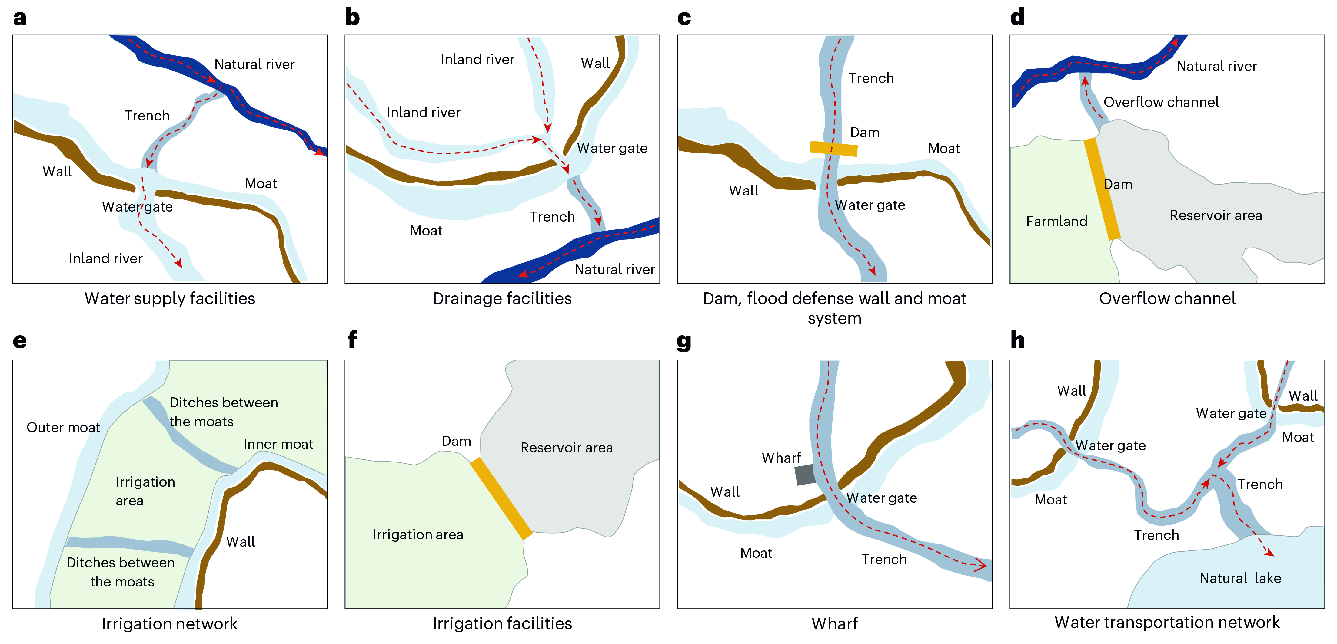
Figure 1. Types of Hydraulic Structures in Early Settlements of the Middle Yangtze River
The study also revealed the dynamic coupling between settlement evolution and changes in the hydrological environment at the regional scale. Taking the Dongting Lake Plain as an example, the expansion of land resulting from the lake’s receding water level after approximately 5.5 ka BP spurred rapid settlement growth, which reached its peak during the Qujialing and Shijiahe cultures. However, following the climatic event at 4.2 ka BP, regional flooding led to a reorganization of the human-land system and a cultural hiatus after the Shijiahe Culture. Subsequently, during the Shang Dynasty, river incision alleviated flood pressure on the plain to some extent, promoting the expansion of settlements along the rivers (Fig. 2).
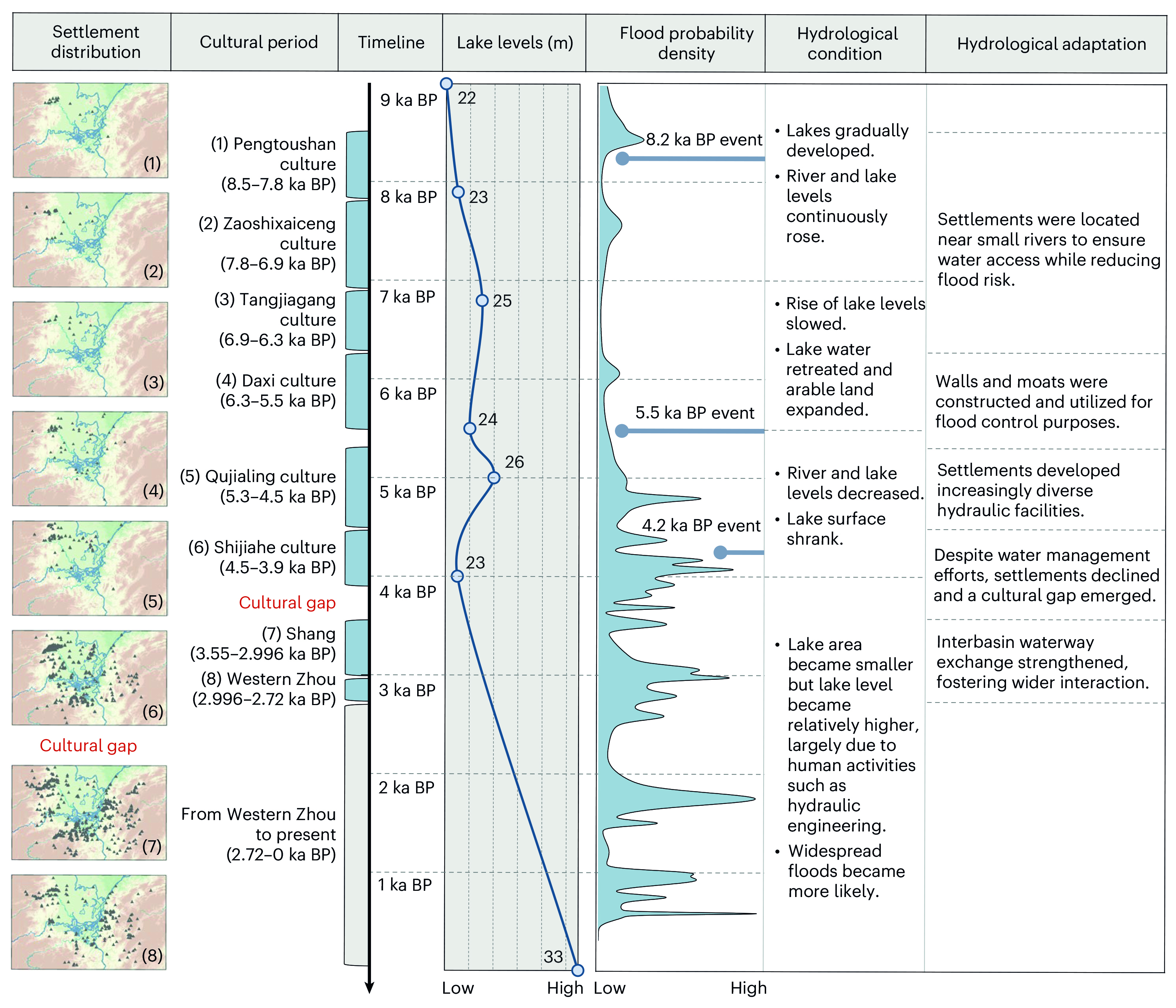
Figure 2. Distribution of Early Settlements on the Dongting Lake Plain and Their Hydrological, Climatic, and Adaptive Contexts
To explain the mechanisms underlying settlement site selection, the research team further analyzed the impact of environmental factors at different stages on settlement distribution (Fig. 3). Model results indicate that as social organization, water management infrastructure, and regional settlement networks developed, the relationship between settlement distribution and local topographic conditions may have undergone adjustments. However, this enhanced adaptive capacity did not entirely prevent the regional decline that followed the Shijiahe Culture, revealing an imbalance between spatial organization, social complexity, and environmental adaptation.
This finding reveals a significant tension in early urban development: while the spatial pattern of settlements continually becomes more complex, hydrological adaptability does not always keep pace. When environmental changes exceed the regulatory capacity of existing infrastructure and organizational systems, settlement systems may experience cumulative vulnerability, potentially leading to spatial reorganization or cultural decline. This study not only contributes to our understanding of the evolution of early civilizations and settlement systems in the middle Yangtze River region but also offers historical insights for the sustainable development of contemporary cities.
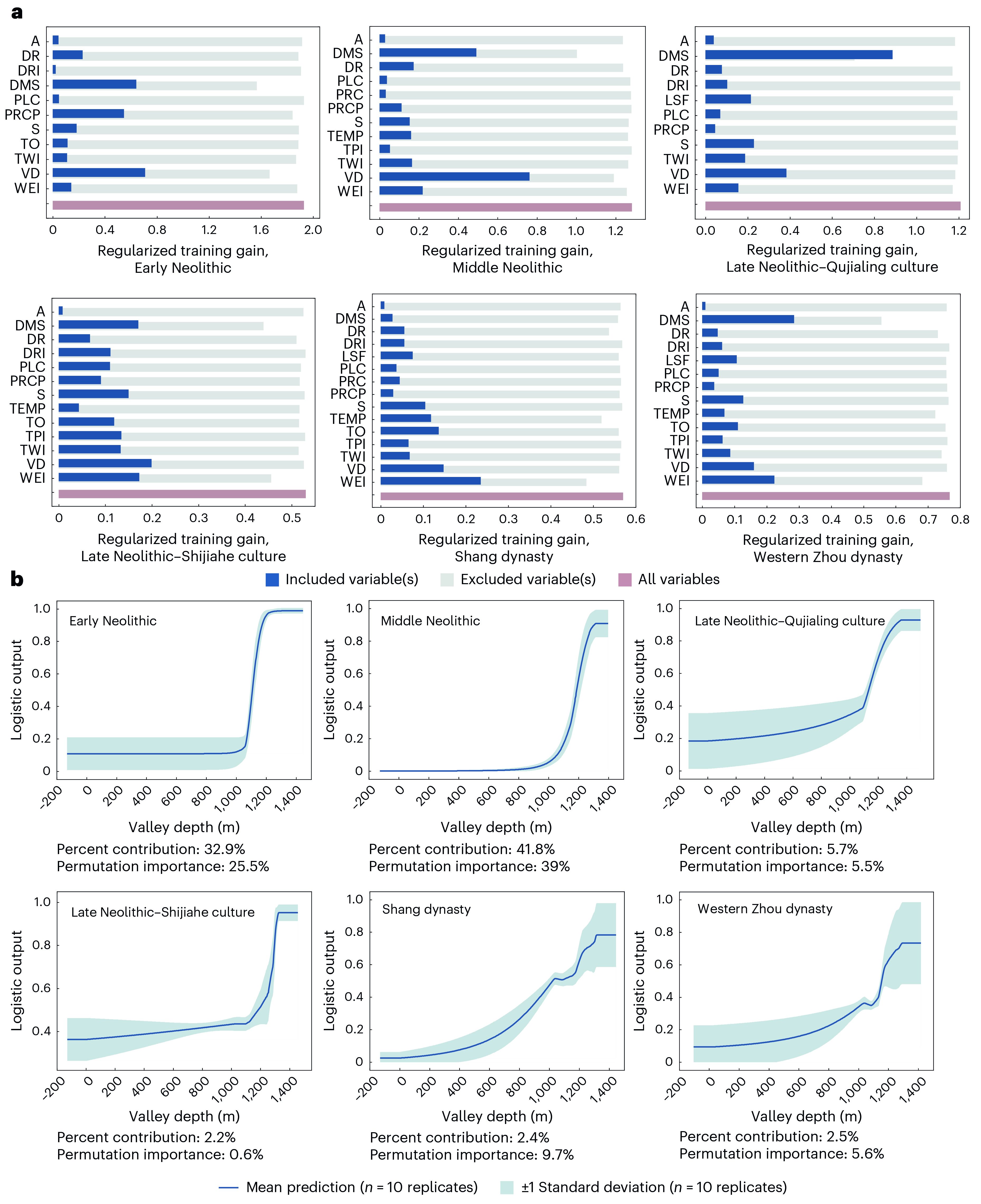
Figure 3. Analysis of Environmental Factors Affecting the Predicted Distribution of Early Settlements Across Different Periods
Wang Fang is the corresponding author of this paper. Zhang Jia’yin, a master’s student at the College of Architecture and Landscape , Peking University, and a Ph.D. candidate in the Department of Geography at the University of California, Santa Barbara; Wang Fang; and Dong Ying, a Ph.D. candidate at the College of Urban and Environmental Sciences, Peking University, are the co-first authors of this paper. Other collaborators include Mao Shaoyi, a Ph.D. candidate at the College of Urban and Environmental Sciences, Peking University; Professor Zhang Changping from the College of History, Wuhan University; Researcher Hu Xie and Professor Liu Jianbao from the College of Urban and Environmental Sciences, Peking University; Researcher Ning Chao and Professor Chen Jianli from the College of Archaeology and Museology, Peking University; Associate Professor Chen Yiyong from the College of Architecture and Planning, Shenzhen University; Researcher Liu Jianguo from the Institute of Archaeology, Chinese Academy of Social Sciences; and Researcher Fang Qin from the Hubei Provincial Institute of Cultural Relics and Archaeology.
This research was supported by the Key Project of the National Natural Science Foundation of China, the first batch of heritage-specific projects under the Major Project of the National Social Science Fund, the National Key Research and Development Program, and the Youth Project of the National Natural Science Foundation of China, among others.
